Guide
How to Get and Use Coordinates in Google Maps Online on Desktop
Unless you work in an area that requires frequent use of GPS coordinates, such as aviation or emergency services, you probably don’t give them much thought. Yet, the combination of longitude and latitude will provide you with an exact position that is much more specific than a street name or home number. Hence, if you find yourself in a position in which you need to seek up GPS coordinates to discover a location or obtain those for a certain spot, you are able to perform both of these things in Google Maps. This tutorial will teach you how to obtain and make use of coordinates in the online version of Google Maps. So let’s get started:
Read Also: How to Use Your Offline Google Maps
How to Get and Use Coordinates in Google Maps Online on Desktop
Get Coordinates Online:
Follow these steps when using the online version of Google Maps to obtain the coordinates for a certain location.
1. Just clicking on a location on the map will drop a tiny, grey pin there.
2. Almost instantly, a little card displaying the location as well as the coordinates will materialize below it.
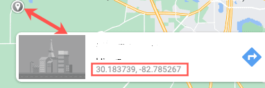
3. When you click on the coordinates, the map will zoom in on the spot, and the information about it will be displayed in the sidebar on the left.
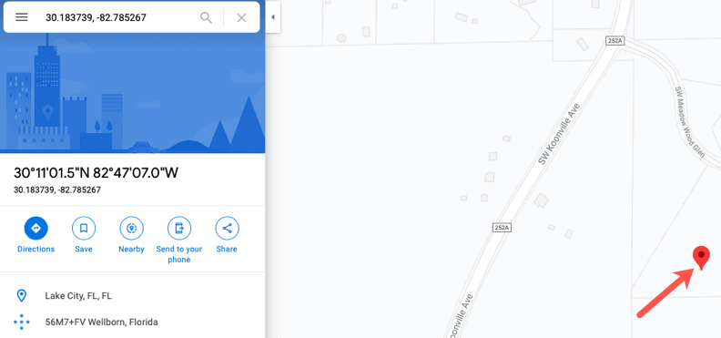
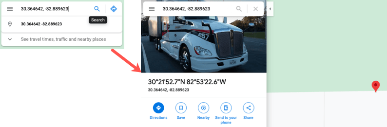
Enter Coordinates Online:
Enter the coordinates manually or copy and paste them into the Search box before clicking the Search button (magnifying glass). Both a giant red pin on the map and facts about your location will be displayed on the left-hand side of the screen.
FAQs
How do I find coordinates without a GPS?
The Earth completes one rotation of 360 degrees throughout the course of one day, which consists of 24 hours. This indicates that one full turn of the Earth takes approximately four minutes (or 15 degrees per hour). If you calculate the amount of time that passes between solar noon at your location and in Greenwich, you will be able to determine your longitude.
Can I use Google Maps as a reference?
Using online maps as a reference (e.g., Google maps)
If you are going to make a reference to a map that you found on Google Maps, the entry in your reference list that you create should include a retrieval date because the specifics of the map are likely to evolve over time. Employ the notation (n.d.) since these maps are considered to be “dynamically created” and do not have a predetermined date of release.
How accurate are phone GPS coordinates?
Under clear sky conditions, GPS-enabled mobile devices, such as smartphones, are often accurate to within a radius of 4.9 metres (16 feet) (view source at ION.org). Unfortunately, their accuracy suffers when they are in close proximity to trees, bridges, and buildings. Dual-frequency receivers and other augmentation devices can help high-end users improve the accuracy of their GPS readings.
What is the difference between GPS and coordinates?
GPS coordinates are a one-of-a-kind identifier that may be used to pinpoint a specific geographic position on the planet. These coordinates are often stated in the form of alphanumeric characters. In the context of this discussion, coordinates refer to points of intersection in a grid system. Latitude and longitude are the two components that are typically combined when expressing GPS coordinates.
Is GPS coordinates the same as latitude and longitude?
Latitude and longitude are the two coordinates that are most frequently used to express GPS coordinates. Latitude lines indicate how far north or south a location is from the equator, and longitude lines indicate how far east or west a location is from the prime meridian. This system divides the earth into latitude and longitude lines. Latitude lines indicate how far north or south a location is from the equator.

Vampire Crawlers Coin Farming Guide

Forza Horizon 6 Performance: Why 60 FPS Is Still the Console Standard

Yoshi and the Mysterious Book (2026) – Full Completion Guide, Rewards & Secret Ending

How to Get Free Pets in Adopt Me: A Guide for Players

Roblox Username Generator – Create a Cool & Unique Username in Seconds
How to Get Free Pets in Adopt Me: A Guide for Players
Yoshi and the Mysterious Book (2026) – Full Completion Guide, Rewards & Secret Ending
Forza Horizon 6 Performance: Why 60 FPS Is Still the Console Standard