How to Find Coordinates on Google Map on Mobile
Even though it has probably been quite some time since you took a geography lesson, concepts such as latitude, longitude, and the Global Positioning System (GPS) probably play an important part in your day-to-day life, particularly if you are a big fan of using Google Maps. If you are looking for a very specific place, such as a precise location in a park where your friends are, or a house in the mountains on a large piece of property, it can be helpful to get the GPS coordinates for a specific location using Google Maps. Getting these coordinates is easy, and it can be helpful if you are looking for a very specific place. The steps of finding coordinates on Google Maps are as follows.
Read Also: How to Change the Language on Google Maps on Android
How to Find Coordinates on Google Map on Mobile
1. On your mobile device running either the iOS or Android operating system, open the Google Maps programme.
2. Either manually enter the location or use the “select and hold” tool to place a pin on the map at the location for which you would need the coordinates. This pin should be placed at the location for which you would require the coordinates.
3. To find the coordinates, scroll all the way down until you reach the bottom of the page.
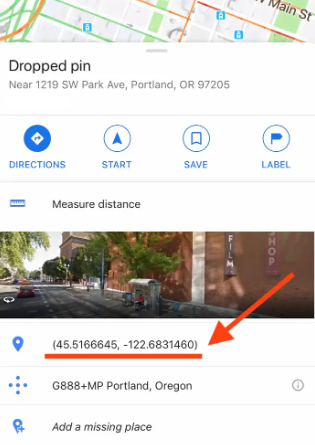
4. To copy the coordinates to the clipboard on your mobile device, tap them after they have been highlighted.
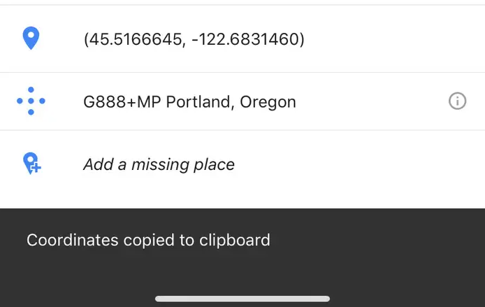
5. Paste the coordinates into the search bar that may be seen at the very top of the screen after you have copied them.
You can also share these coordinates with other people by copying and pasting them into a text message or an email and sending it to them. If you want to give your contacts information about a very specialized subject, this is a good option to go with because it gives you more control.
FAQS
How do coordinates work?
Lines of latitude and longitude are the building blocks of the geographic coordinate system. Each line of longitude extends from north to south and provides a reading that indicates the number of degrees to the east or west of the prime meridian. The values range from -180 to +180 degrees Celsius. Latitude lines are drawn running east to west and are used to measure the number of degrees north or south of the equator.
What are coordinates on a map?
GPS coordinates are a one-of-a-kind identifier that may be used to pinpoint a specific geographic position on the planet. These coordinates are often stated in the form of alphanumeric characters. In the context of this discussion, coordinates refer to points of intersection in a grid system. Latitude and longitude are the two components that are typically combined when expressing GPS coordinates.
Why do we use coordinates?
It is common practise to utilise coordinate systems in order to indicate the location of a point; however, same systems can also be used to specify the location of more complex objects, such as lines, planes, circles, or spheres. For instance, the location of a line in space can be determined by using something called Plücker coordinates.

Roblox Username Generator – Create a Cool & Unique Username in Seconds

Grow a Garden Recipes in Roblox: Guide to Cook (Donuts, Sushi, Pie, Pizza & More!)

Job Opportunities in Dubai – 2026

Mr Bit at the SBC Awards Europe 2025: The Bulgarian Brand Setting New Standards in the European Gaming Industry

Dennis Rodman Net Worth 2026 – Everything You Need to Know

Bloxburg Neighborhood Codes 2026
Grow a Garden Recipes in Roblox: Guide to Cook (Donuts, Sushi, Pie, Pizza & More!)
Job Opportunities in Dubai – 2026
Dennis Rodman Net Worth 2026 – Everything You Need to Know